Maps
Maps

Maps are one of the most straightforward diagrams to describe in IELTS Writing Task 1. Why?
You just have to describe one map, and how it has changed in the other map. It is easier to get a high score because you have to make comparisons, and you can logically organise your data simple (e.g. go round the map clockwise).
The challenge with this task response lies in your vocabulary choices and the use of passive voice. More on that below...
Something a little different...

Remember, we use passive because we want to focus on the object (how it's changed) and not who did it.
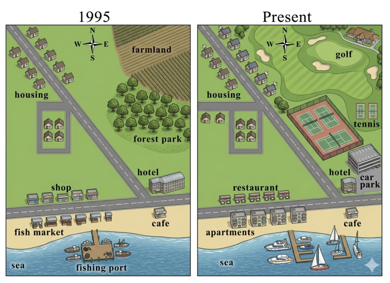
5 active voice sentence to describe this map:
- The city replaced the fish market and the fishing port with a row of apartments and a modern marina.
- Developers converted the old farmland and forest park into a golf course and tennis courts.
- A new restaurant took the place of the original shop along the main road.
- The hotel added a brand-new car park right next to its main building.
- Construction workers built several new houses along the straight road in the north-west sector.
Changed to passive voice...

Location, Location, Location
Map tasks require strict location precision.
Examiners hate it when students write "at the top" or "on the left."
Examples:
Instead of: "At the top left..."
The Upgrade: "In the north-west quadrant..." or "Along the northern perimeter..."
Instead of: "Next to the school..."
The Upgrade: "Flanked by the school..." or "Situated immediately adjacent to the educational facility..."
Instead of: "The road cuts the town in half..."
The Upgrade: "A primary thoroughfare bisects the urban center..."

Model Essay Example
Self-analysis tip:
Your essay should be so good that when someone else reads it, they are able to draw the graph.
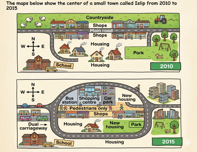
The maps illustrate the urban development in Islip town center between 2010 and 2015. Overall, the town center underwent significant modernization, transitioning into a pedestrianized commercial zone encircled by a new ring road, alongside a substantial expansion of residential housing.
In 2010, a main road bisected the town from east to west, flanked by shops. Housing sat to the south, alongside a southwest school and a southeast park, while the northern perimeter was entirely countryside. By 2015, the central main road was converted into a pedestrian-only zone. To manage traffic, a dual carriageway was constructed as a ring road completely encircling this central commercial district.
Major infrastructural developments occurred within and around this loop. The northern row of shops was demolished to introduce a shopping centre, a bus station, and a car park. Furthermore, the northern countryside was replaced by multi-story apartments and new housing. In the southeast, additional housing was built, reducing the park's size, while further residential developments were introduced just east of the unaltered school.
Task achievement
Complete Coverage: Every single change between 2010 and 2015 is accounted for (the ring road, pedestrianization, the shopping center, the bus station, the car park, the multi-story apartments, and the reduced park).
Clear Overview: The first paragraph features a clear summary of the overall trend (modernization, pedestrianization, a ring road, and housing expansion) without getting bogged down in specific numbers or details.
Coherence & Cohesion
Seamless Flow: Cohesive devices are used naturally and sparingly ("Overall", "By 2015", "Furthermore", "While"). They do not feel forced or repetitive.
Clear Referencing: It utilizes precise spatial referencing ("within and around this loop", "just east of the unaltered school") to guide the reader through the map.
Lexical Resource
Precise Map Vocabulary: It relies on high-level vocabulary tailored specifically for map tasks ("bisected", "flanked", "perimeter", "encircling", "demolished", "unaltered").
Natural Collocations: Uses precise word pairings rather than awkward translations ("pedestrianized commercial zone", "multi-story apartments", "residential capacity").
Grammatical Range & Accuracy
Passive Voice Mastery: Map essays require heavy use of the passive voice to describe changes where the actor is unknown, which this essay does continuously ("was converted", "was constructed", "was demolished", "were introduced").
Complex Structures: It embeds dependent clauses to pack maximum information into few words ("In the southeast, additional housing was built, reducing the park's size, while further...").
SCORE
TA - 9
CC - 9
LR - 9
GA - 9
Overall: 9
While minor differences exist between individual examiners, this essay comfortably clears the Band 8.5 threshold due to its complete absence of grammatical errors, precise mathematical reporting, and native-like lexical control.